Pollinators
The generally observed decline of flying insects includes pollinators. A better understanding is therefore needed of how land use practices, in particular in agriculture, affect pollinators. One important pollinator species are honey bees (Apis mellifera). They are managed and can therefore not represent all pollinators, but the wealth of data and knowledge available for honey bees, and their high level of public attention, has made them a key species of concern, for example for pesticide risk assessment.
This BioDT use case thus focusses on honey bees, but the workflows for including data on land use and weather can also be adapted for other pollinator species and ultimately for addressing species interactions in pollinator communities, for example competition between honey and wild bees. We will examine how different spatial land use practices, climate scenarios and beekeeping practices affect the vitality and survival of honey bee colonies. The use case is located in Germany and the ultimate aim is to produce a map assessing the quality of the landscape for honey bee vitality and survival.
We will populate the well-documented and freely available simulation model BEEHAVE, which has been used in more than 20 studies for specific areas around a single colony. We will use publicly available land use maps that are based on Sentinel 2 data and classify each 20 m x 20 m pixel of Germany with one out of 19 major land use types. Weather data will be assessed through the rdwd R package that identifies the nearest weather station of the German Weather Service and downloads the needed data for example the maximum daily temperature and daily sun shine hours.
These land use and weather data are used as the two the main drivers for BEEHAVE. For validation and calibration, publicly available TrachtNet data on daily stock weight changes of more than 500 hives will be used. These data inform about the daily amount of nectar collected, and consumed, by a colony, which can be compared to BEEHAVE output.
Pollinators and Digital Twin Models
Two twin applications are envisioned for the BEEHAVE model. The first will cover the hives of the TrachtNet. For the second, BEEHAVE will be run on a raster covering entire Germany at a resolution of 3 km. These computationally demanding simulations will be run on LUMI. While the prototype twins developed in BioDT will address Germany, the worksflows used can be extended to other countries, and given the availability of the data needed, in principle to entire Europe.
FAIR principles will be addressed, for example Input data used for the modelling will be referenced using persistent identifiers if possible. Together with our project partner we embed our workflow in an environment such as LEXIS. It is planned to store the metadata of the runs alongside versions of the used software according to the Fair Digital Objects that will be created in WP5 – Improving Quality of Data, Workflows and Models through FAIR Principles.
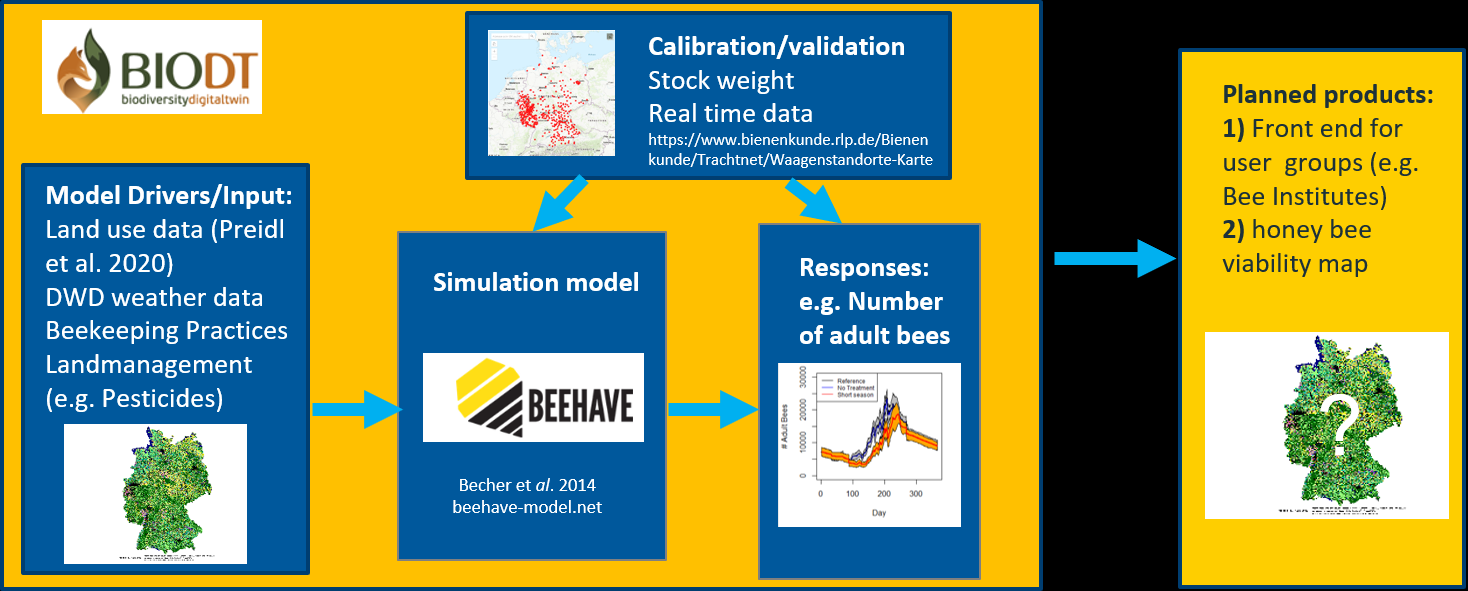
Land-use and weather data are used to update the drivers of the simulation BEEHAVE, which represents a single honey bee colony. Daily data on stock/hive weights are used to calibrate and validate BEEHAVE. The re-calibrated model is then used to map bee vitality and risk of winter losses of coloney for entire Germany
Use case leader and co-leader: Volker Grimm and Jürgen Groeneveld, Helmholtz-Centre for Environmental Research-UFZ, Leipzig
Partners involved